Determining the boundaries of a land plot by cadastral number, address and location?
Content
- 1 Legislation of the Russian Federation
- 2 Where can I find out the boundaries of a land plot?
- 3 What lands are subject to registration?
- 4 How to find out the boundaries of land by cadastral number
- 5 How to check the boundaries of a land plot by number
- 6 Important points
- → Ask a question to a lawyer → free consultation ↓
The simplest and most accessible option to find out about the boundaries of a land plot is to use the cadastral number of the specified property to submit a request to the authorized agency of Rosreestr or the MFC.
Since the purchase or sale of a land plot requires specifying the exact parameters of the object, this information must be obtained in advance so as not to delay the transaction.
Legislation of the Russian Federation
Starting from 2013, all information about real estate is subject to collection and recording during the registration process with government agencies.
Since the beginning of this year, Law No. 218-FZ has been applied throughout the country, which provides for new rules for cadastral registration and registration actions in relation to each object, including plots of land.
The boundaries of your land plot are determined as a result of work to determine the size of the plot and the preparation of a boundary plan, however, only approximate information can be obtained from this document.
The boundary plan must be sent to the Rosreestr office, and after the site is registered for cadastral registration, official information about the boundaries will be entered into the Unified State Register of Real Estate.
Land plots are registered in the cadastral register taking into account the following nuances:
- when determining boundaries, the engineer indicates the location of the site on the ground, and also coordinates the boundaries with the owners of adjacent plots;
- to officially determine the established boundaries of a land plot, the engineer indicates their coordinates on a graphic plan and also describes them in text form;
- Based on the results of registering an object, the copyright holder is issued a cadastral passport for the land plot (formally, at present, instead of a passport, an extract from the Unified State Register is issued).
A unique cadastral number is assigned to each land unit based on the results of registering the object, after which it can be accurately identified using this numerical code.
Where can I find out the boundaries of a land plot?
You can determine reliable and accurate boundaries of the allotment using the following options:
- from the title document, which is currently an extract from the USRN register;
- by sending a request for an extract from the specified database (any interested person can check the data in this way, since the Unified State Register of Real Estate operates on the principles of openness and accessibility to the public);
- by submitting an electronic request through the government services portal;
- through familiarization with the open data of the official electronic resource - the Public Cadastral Map .
For this type of application, you must first check whether the plot of land is registered, since the cadastral number will only be assigned to an object that has undergone the specified procedure.
The cadastral number of the land plot can be viewed in the cadastral passport (extract from the Unified State Register of Real Estate), however, only the owner of the land can obtain this document.
This form indicates the exact coordinates of the boundaries on the map, and the boundary plan will allow you to determine the location of the site on the ground.
What lands are subject to registration?
Currently, all newly formed plots allocated from municipal or state fund lands are subject to registration with the cadastral authorities.
If land rights were registered before 2013, registration will be carried out during the process of registering transactions with this object.
Only an engineer who has a valid certificate and is a member of one of the self-regulatory organizations has the right to determine the boundaries of a land plot.
His tasks include carrying out work on the ground and drawing up a boundary plan, after which the land plots are subject to cadastral registration.
How to find out the boundaries of land by cadastral number
If an interested party wants to determine the boundaries of a land plot, he only needs to find out the cadastral number.
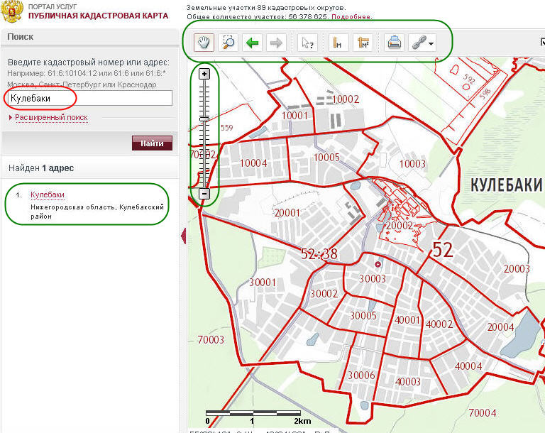
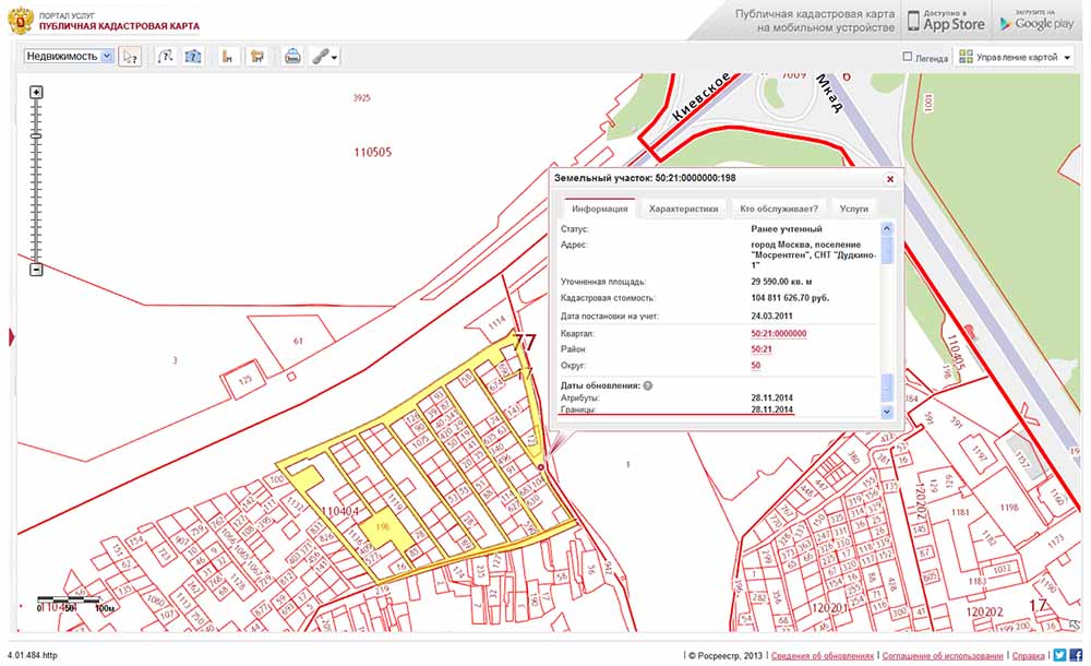
This can be done even without contacting the Rosreestr service - you need to go to the electronic resource of the Public Cadastral Map and select the object of interest on the graphical diagram of the country.
The offered card will indicate the required number by which you can make an official request.
Using the available number, you can quite simply determine the boundaries of the area of interest:
- contact the Rosreestr service, the MFC or through the government services portal (to do this you only need to go through official verification on this portal);
- pay the state fee for issuing an extract from the Unified State Register of Real Estate;
- fill out a request in writing or electronically, indicating a digital code;
- receive an official document - an extract from the register indicating the size of the plot.
Thus, using the cadastral number, it is quite easy to determine the boundaries of the plot, since each plot of land is officially registered in the Unified State Register of Real Estate.
If information is not provided upon the submitted request, this indicates a lack of registration with government agencies.
In this case, you can find out exact information about the boundaries only through the copyright holder, who has the boundary documentation for the land.
How to check the boundaries of a land plot by number
Even if the owner or owner of the land has a boundary plan or cadastral passport in hand, the possibility of a technical or registry error cannot be ruled out.
In this case, the same cadastral number of this plot will help to check the boundaries of the land plot for their accuracy and reliability.
To verify the information, you need to request a current extract from the USRN register, and then compare the data with the title documents.
If technical or registry errors are detected, the owner must contact:
- to the Rosreestr service to eliminate a technical error (misprint, etc.);
- to the cadastral engineer to carry out repeated work, and then receive an updated boundary plan;
- to re-register the object to correct the registry error.
If, during repeated cadastral work, the owners of adjacent plots refuse to agree on new boundaries in the boundary plan, the copyright holder has the right to apply to the judicial authorities to protect their interests.
In this case, clarification of the size of the plot in the information of the Unified State Register of Real Estate will be carried out on the basis of a judicial act.
Important points
Accuracy of boundaries plays a key role in preparing for land transactions. When selling a plot, it is transferred from hand to hand; its boundaries are determined not only by the terms of the contract, but also by proper boundary documentation.
At the same time, the seller has the legal right to receive complete and reliable information about the purchased property.
Since, when registering transactions with land plots, the parties need to apply for registration with the Rosreestr service, it may be necessary to simultaneously register the property.
Currently, the legislation provides for the simultaneous carrying out of accounting and registration actions, which will significantly reduce the time required for verification and execution of the necessary documents.

