Boundaries of a land plot by cadastral number - where to look
Content
- 1 Legislation of the Russian Federation in this matter
- 2 Where can I find out the boundaries of a land plot?
- 3 What plots of land can be registered in the cadastral register?
- 4 We find out the boundaries of a plot of land by cadastral number
- 5 Checking the correctness of the assigned boundaries
- 6 Important point
- → Ask a question to a lawyer → free consultation ↓
The formation of new land plots is carried out during registration, as a result of which this object is assigned a unique numerical code - a cadastral number. After this procedure, you can find out the boundaries of the land plot by cadastral number, and if an error is identified, you can promptly apply for its correction.
Legislation of the Russian Federation in this matter
Each land plot is recognized as an immovable object only after its boundaries, as well as other essential parameters, have been established.
The formalized process of determining the size makes it possible to select specific land plots from the general composition of the territories of the municipal and state fund, after which these objects become available for registration of rights and subsequent disposal.
The boundaries of the land plot are determined on the basis of the following regulatory legal acts:
- Land Code of the Russian Federation;
- Federal Law of July 13, 2015 No. 218-FZ;
- Federal Law of July 24, 2007 No. 221-FZ.
It is these documents that are the basis for the activities of an engineer who is engaged in determining the boundaries of a land plot during land works.
The result of the actions of this specialist is reflected in boundary documents, which must be sent to Rosreestr institutions for registration of the formed object.
Based on the results of registration activities and placement of information in the Unified State Register of Real Estate, citizens receive a cadastral passport for the land plot.
The cadastral number of this plot is recorded in this document and can be used when purchasing a land plot or its alienation to third parties.
Where can I find out the boundaries of a land plot?
At the stage of preparation for concluding an agreement regarding land, it is necessary to check and establish legally significant information about the subject of the transaction.
If a potential buyer plans to acquire ownership of a land plot, he can conduct a preliminary analysis of the essential terms of the transaction, having the numerical code of this object.
Where can I see the boundaries of a land plot if I know the cadastral number? You can find out in the following ways:
- contact the territorial division of Rosreestr with a request to provide an extract from the Unified State Register of Real Estate in paper form;
- submit a similar request through the official website of government services, as a result of which an extract from the Unified State Register will be presented in the form of an electronic document;
- look at the necessary information in the cadastral passport;
- by searching for an object through the Public Cadastral Map, which contains information about each property registered.
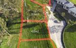
Of the above options, the public map of Rosreestr (website - http://pkk5.rosreestr.ru ) makes it possible not only to obtain data on the characteristics of the plot, but also to see the established boundaries of the land plot in visual form on the area map.
When a site is registered for cadastral registration, its publicly available characteristics are posted on the specified public resource and are available for review by anyone.
What plots of land can be registered in the cadastral register?
All territories formed from unallocated lands of the state and municipal fund are subject to cadastral registration.
It is this procedure that allows you to register various forms of rights to it and introduce the object into economic circulation.
Land plots are subject to cadastral registration after the occurrence of the following legally significant actions and decisions:
- allocation of allotment according to the administrative act of the authorities (decree, etc.);
- acquisition of land at auctions held by authorized bodies;
- formation of accounting units after division or allocation of new units;
- when registering plots allocated to individuals or acquired legally, before the introduction of a cadastral registration system in the Russian Federation.
For any of the above reasons, the result of accounting procedures will be a cadastral passport. To determine the boundaries of a land plot for the production of a passport, their characteristic points are used, recorded by the engineer in the boundary documentation.
The accounting authorities transfer the information received by the engineer during the land surveying work to the register information.
In this case, the assigned number remains with the site for the entire period of its existence and is canceled only in the following situations:
- deregistration when the plots are merged into a new unit;
- when dividing a single plot into several new independent objects.
In these cases, new units will be assigned their own unique numbers, and information about their boundaries will be entered into the Unified State Register of Real Estate.
We find out the boundaries of a plot of land by cadastral number
Determining the boundaries of a land plot by cadastral number can be done using one of the above methods. Using the cadastral number, it is quite easy to determine the boundaries of the plot of interest through the Public Map of Rosreestr on the website http://pkk5.rosreestr.ru.
To do this, you need to indicate the unique numeric code of the object in the information search window, after which the electronic resource will indicate its location on a visual map of the area.
In addition to the graphic information that the Public Map of Rosreestr will provide, to check the boundaries of a land plot, you can find out their geographic coordinates from the information in the Unified State Register or passport extract.
The resulting geographic points can be compared with government topographical maps.
Therefore, in order to obtain reliable and up-to-date information about the object of interest, it is enough to know its cadastral number assigned in the process of accounting procedures.
Checking the correctness of the assigned boundaries
In a number of situations, the fact of determining the boundaries of a land plot by cadastral number makes it possible to identify shortcomings in the accounting information of the Unified State Register of Real Estate. Such errors not only lead to distortion of objective information in the register, but also will not allow full disposal of the property.
Errors may occur as a result of the following circumstances:
- technical violations committed during the preparation of boundary documentation;
- technical violations committed when transferring the parameters of boundary documents to the information of the Unified State Register of Real Estate;
- disturbances caused by crossing or overlapping boundaries of adjacent adjacent accounting units.
In this case, the coinciding boundaries of the land plot by cadastral number will be clearly visible on the graphic diagram of the Public Map, or the coordinates of the points of their boundaries will coincide by one or more values.
To eliminate the error, you will need to contact the engineer again or resolve the conflict regarding disputed plots through legal proceedings.
Important point
After the formation of a new site and the establishment of its boundaries in the boundary plan, the newly formed one is subject to registration in the territorial bodies of Rosreestr.
The assigned cadastral number of a land plot will allow you not only to individualize it among other accounting units, but also to find out the main characteristics of the object.
Thus, having only information about the unique numerical code of the plot, you can clarify its location and boundary points in various ways. This information will be necessary when preparing to conclude a transaction or verify the accuracy of the USRN information.