Act of approval of the boundaries of the land plot, basic requirements
Content
- 1 What is an act of approval of the boundaries of a land plot?
- 2 Legislation of the Russian Federation in this matter
- 3 Steps to Establish Boundary Locations
- 4 The process of agreeing on the delimitation of land allotment
- 5 Basic moments
- 6 Parties
- 7 Stages of document preparation
- 8 Sample
- 9 Document requirements
- 10 Objections
- → Ask a question to a lawyer → free consultation ↓
Determination of characteristic points of the boundaries of land plots is carried out based on the results of the work of the cadastral engineer. Since the establishment of the actual boundaries of a plot inevitably affects the interests of the owners of adjacent plots, the law establishes special rules when agreeing on the delimitation of plots. Under these circumstances, it is necessary to draw up an act of approval of the location of the border of the land plots.
What is an act of approval of the boundaries of a land plot?
Coordination of the location of the actual boundaries of adjacent areas is formalized in the form of an independent act. This form is prepared based on the results of cadastral activities that are required to register a site with the Rosreestr service.
The location of the site boundaries will be determined taking into account special nuances:
- the authority to determine the boundaries of the plot belongs to a professional specialist - a cadastral engineer;
- the basis for performing boundary and cadastral work is the conclusion of a contract agreement with an engineer;
- the land plot, the boundaries of which were recorded by the engineer in the boundary plan, will be registered only after the boundaries of the site have been agreed upon with the neighbors.
Only the owner of the land who has the proper permits can order boundary work. It is often necessary to carry out these types of work on lands of joint and shared ownership, to establish the actual boundaries of the individual shares of each owner.
Legislation of the Russian Federation in this matter
The requirement for coordination of land boundaries is regulated by the following regulatory legal acts:
- Law No. 218-FZ, which defines the conditions for cadastral registration and registration actions in relation to plots of land;
- Land Code of the Russian Federation, which establishes the legal regime of various lands in the Russian Federation;
- Law “On Cadastral Activities” regarding the powers of engineers when carrying out cadastral and boundary work;
- The Law “On Land Management”, which establishes general rules for dealing with land plots.
The requirements for the act of approving the boundaries of a land plot, as well as a new form of the act, were put into effect in January 2017 with the adoption of Law No. 218-FZ.
To determine the boundaries of plots, the laws of the Russian Federation provide for pre-trial and judicial procedures for approval, which will resolve any disputes between owners of adjacent plots.
Steps to Establish Boundary Locations
When establishing the actual boundaries of a site, an authorized representative of government agencies will have to perform the following mandatory actions:
- obtain title documentation from the land owner, including information about previously established boundaries;
- conduct a survey and record the boundaries of the plot on a graphic diagram and on the ground;
- coordinate the boundaries of the site with neighbors, for which purpose draw up an approval act;
- if the owners of adjacent plots disagree with the definition of boundaries, include their objections in the act;
- Disagreements recorded in the act shall be submitted by agreement to the judicial authorities.
If all neighbors agree with the establishment of boundaries, the act is attached to the boundary plan and sent to the Rosreestr service to register the property for cadastral registration.
The process of agreeing on the delimitation of land allotment
If the delimitation of a land plot is agreed upon, neighbors have the right to participate in this procedure by filing objections, as well as challenging the results of cadastral work.
If at the approval stage the neighbors have no objections, they must agree and sign an act to this effect within 30 days from the date of receipt of the document.
If there are no objections, after 30 days from the date of delivery of the approval act, the cadastral engineer notes this fact in the act and sends the boundary plan to the Rosreestr service.
If there are objections, the engineer re-executes the approval document and again sends it to the owners of adjacent plots. If, upon re-approval, objections are again raised, the dispute is referred to the judicial authorities.
Basic moments
Coordination can be carried out not only at the initiative of the land rights holder. The following additional reasons for carrying out this procedure can be identified:
- identification of a registry error by Rosreestr officials, as a result of which additional cadastral work is required;
- presentation of claims by one or more owners of plots whose boundaries need to be agreed upon for violation of their rights by previously carried out land surveying;
- division or allocation of a land plot, as a result of which a dispute may arise between the copyright holders of one object.
Before approval, you must first find out the existing boundaries of the site by cadastral number , and each land owner must take part in the agreement.
Unlawful exclusion of at least one of the owners from this procedure will entail a violation of his rights and will provide an opportunity to challenge the act and boundary plan in court.
Parties
At the stage of determining the size of the allotment, fixing them in text and graphic form, as well as approving the act, the following parties can participate:
- the customer of boundary work is the legal holder of the allotment;
- an engineer whose powers include carrying out work on preparing a boundary plan and drawing up the necessary documentation;
- owners of neighboring plots of land that have a common line with the surveyed plot;
- officials of Rosreestr, if, on their initiative, the boundary plan is aimed at finalization and coordination with neighbors.
The owners of the plots are directly involved in the preparation of such a document, and they are obliged to sign it or submit objections. Coordination is carried out in two possible options - at a general meeting of all interested parties or by reviewing the act in absentia.
Stages of document preparation
After carrying out cadastral work and establishing characteristic points of the boundaries of the site, the engineer must approve them. This procedure consists of the following mandatory steps:
- execution of the act in writing, where text and graphic data about the location of the surveyed area are entered;
- signing of the act by the copyright holder (customer of cadastral work);
- sending the act to the owners of adjacent plots or delivering the document to them personally against signature;
- if objections are received about the location of the borders, repeated cadastral work is carried out with the drawing up of an updated act;
- if all the owners of neighboring plots have signed the agreement on the boundaries in the act, the document is filed with the boundary plan for the plot;
- If, upon re-approval, a positive decision is not received from all participants in this procedure, the dispute is referred to a judicial authority.
Where to submit the drawn up border approval acts? The cadastral engineer is obliged to include them in the boundary plan and send them in electronic form to the Rosreestr service. The specified department will carry out cadastral registration of the land plot, and information about the boundaries will be entered into the real estate register of the Unified State Register of Real Estate.
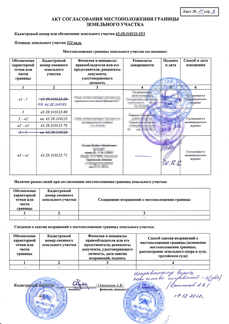
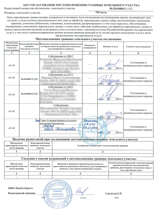
Sample
The act of coordinating the boundaries of a land plot in 2017 with neighbors on land plots is drawn up taking into account the rules provided for by Law No. 218-FZ, and a sample of the specified document can be downloaded on our website.
Download a sample act of approval of the boundaries of the site.
Document requirements
The list of requirements for the new approval act is established by Law No. 218-FZ, and the key innovation in this procedure is the obligation to send the specified document in electronic form directly to the cadastral service of Rosreestr.
If disagreements between neighbors have not been resolved voluntarily, the document will be sent in writing to the judicial authority at the request of the interested parties.
Corrections in the act of approving the boundaries of a land plot are allowed only if they are made before the final execution of the act and its sending to the cadastral authorities. In this case, only the cadastral engineer has the right to make corrections, and all interested parties must be notified of the amendments made.
If there were violations when drawing up the act, including when notifying all interested parties, the document can be challenged in a judicial body.
To do this, an interested party (for example, the owner of one of the plots) sends an application to the court to invalidate the boundary plan, which includes the act.
If the boundary plan and act are cancelled, cadastral work must be carried out again. In this case, a new approval of the boundaries of the land plot will be required in compliance with legal requirements.
Objections
The possibility of filing an objection is a guarantee that the interests of interested parties are respected. Objections may be made on the following grounds:
- intersection or overlap of previously defined edges of adjacent areas;
- reduction in the area of neighboring plots by more than 5%;
- unreliable determination of the coordinates of characteristic points of the boundaries of the surveyed area, which violates the interests of other rights holders;
- discrepancy between the established boundaries and previously registered information and rights to real estate in the Unified State Register of Real Estate.
Objections are made in writing, and the cadastral engineer is obliged to include them in the contents of the act in an unchanged form.
When sending a repeated approval act, interested parties can also file objections, which will later be considered in court.
The law provides for restrictions on drawing up an approval act and filing objections - this procedure is not required for agricultural land; for lands under linear objects and communication lines, as well as in some other cases. If, during the surveying of these objects, violations were committed by the owners of neighboring land plots, they have the right to present their objections in court when challenging the cadastral registration results.

