How to quickly find out whether a land plot has been previously surveyed
Content
Transactions on areas for which coordinates and boundaries have not been determined will become impossible in the near future. From January 2018, new rules will come into force requiring all land owners intending to sell or enter into other transactions with land plots to carry out boundary surveys. It is likely that this operation in relation to the allotment has already been carried out. Finding out whether there is a land survey is quite simple.
What do you need to know to check?
The verification begins with the need to determine the cadastral number (CN) assigned to the dacha plot or any other plot during its registration and state registration.
Accordingly, it can be found in the cadastral passport, certificate of ownership, contract and other documents that were drawn up at the time of its acquisition.
In addition to his documents, the owner of the site can find out the CN in Rosreestr by contacting the service in person or via the Internet. If the requested information is not in the Unified State Register of Real Estate, it means that the site is not included in the register, and accordingly no land surveying was done. The service is paid: in order to receive an extract from the Unified State Register (USRE), you need to pay a state fee .
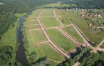
The cadastral number is formed in accordance with the territorial affiliation of the site. For example, cadastral number 47:14:0412004:29 includes a plot located at the address: Leningrad region, Lomonosovsky district, SNT “Novosel”, st. Parallel, section No. 28 .
This information is provided free of charge. Try it yourself - http://pkk5.rosreestr.ru .
Was there land surveying?
Accurate information about land surveying is available in the Unified State Register of Real Estate. Accordingly, the owner of the land plot, who knows the CN, has the right to make a request to Rosreestr and receive there a cadastral passport (CP) or an extract, on the basis of which to decide the issue of land surveying.
See >> Pros and cons of the land surveying procedure .
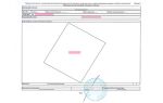
To determine whether land surveying took place, using a cadastral passport and a cadastral extract, it is necessary to study their contents. These documents include written and graphic information about the site, including its area, boundaries, and position.
So, if land surveying was carried out, then the documents contain the relevant information. It is recommended to analyze the following sections:
- Special notes (section No. 16, its number is the same for both the passport and the extract). The absence of land surveying is characterized by the following entries:
- boundaries are not established;
- boundaries are determined by linear measurements;
- the boundaries are set in a system of conventional coordinates.
Another option in which such records are possible is that the survey work was carried out with violations.
- Area is a secondary aspect that confirms whether land surveying is done or not. With a high degree of probability, it can be stated that land surveying was not carried out if the area is indicated in a round number, for example, 100 square meters. m., and has no additional notes. Another option: there is an error, but it also has an integer value, for example, +/- 15 square meters. m. The considered feature does not guarantee that there is no land surveying, but it indirectly confirms this.
- Turning points are included in the cadastral extract (CR). The essence of turning points is that for each type of land the error of the boundary points is established. If the values indicated in the extract exceed the permissible limits, then the survey was carried out in violation, and it is invalid.
The error values are as follows for the territories:- settlements - 0.1;
- lands intended for agriculture or individual housing construction - 0.2;
- other agricultural land - 2.5;
- lands of industry, energy, defense, transport - 0.5;
- lands of protected areas - 2.5;
- lands of water, forest funds and reserves - 5.
You can consult on land surveying issues for free on the website. The specialist will examine the documents specifically for your plot and determine whether the procedure for determining the boundaries of the plot was carried out. You can contact a lawyer through feedback, or by calling.
You can check the presence of land surveying via the Internet in several ways:
- issue an extract from the Unified State Registration Register , a cadastral extract or a passport on the Rosreestr website;
- use public cadastral map data for free.
The latter option is possible if you know the site's code or its exact address. All areas are shown on the map, even those located in SNT.
Thus, if land surveying has not been carried out for a land plot, then its survey plan is not displayed on the public cadastral map. In this case, the displayed table with parameters contains the entry “ without border coordinates ”.
Obtaining information after surveying
Information on determining the boundaries of the land can be found in the documents that are in the hands of the owner. For example, land surveying is determined by a cadastral passport, an extract, or an extract from the Unified State Register of Real Estate.
In addition, the use of network services is allowed, one of which is a public cadastral map. If there is no land marking on the map, then the site plan is not displayed. On the contrary, when the land plot is surveyed, information about the location, postal address, and boundaries will be displayed for the plot.
If there is a land survey, then the owner has the right to dispose of the property at his own discretion, otherwise he will have to do it himself.