Cadastral error: how to prove and correct it
Content
Inaccuracies in the cadastre are errors that appeared during the registration of state registration. registration, documentation for real estate, in particular for land. Correction of cadastral errors is required if the documents submitted to the cadastre registration organization contain incorrect data. For example, inaccuracies may be made when determining coordinate points indicating the boundaries of a plot of land.
Types of cadastral errors
Cadastral error - what is it? - some people who have encountered a similar problem are interested.
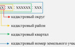
A cadastral error (CE) is an inaccuracy or miscalculation that is entered into the Unified State Register of Real Estate and in fact does not correspond to the real situation.
Errors of this kind can be made by representatives of local government bodies or state authorities who incorrectly drew up the layout of the land plot.
Taking into account the information from the draft boundaries, work is carried out and other acts are made that establish/change individual parameters of land plots:
- permissible intended use;
- land category;
- accommodation, address.
It is also possible for a cadastral engineer to make a mistake - this is an incorrect display of information regarding the coordinates (boundaries) of the land plot in the boundary plan. Cadastral miscalculation is sometimes made by local government employees when preparing a project that indicates the boundaries of a site, when performing an inventory and drawing up various acts that change its characteristics.
If you need to correct a cadastral error, you can contact a notary or lawyer on the website . Qualified specialists will carefully consider your request and advise how to solve the problem. They can also provide assistance in case of cadastral calculations of land plots, regardless of their complexity.
Examples of errors in the cadastre
It is easy to correct a cadastral error of any land plot if you know what it is. The following are examples of common mistakes:
- the decision regarding the provision of a land plot does not contain its address, while other data does not correspond to those stated by the State Committee for Taxation;
- information regarding the intended purpose of the land does not match in the cadastral passport and the Certificate of Ownership;
- correction of the allotment area on the basis of a certificate issued by a local government body.
Incorrect coordinates of the boundaries of land plots are considered to be incorrect. If you are not able to correct an error in the cadastral passport or in the Unified State Register on your own, you cannot do without the help of professionals. Otherwise, without the appropriate knowledge and experience, getting rid of the problem will take many years.
Why miscalculations occur
Practice shows that most often technical errors arise due to the fault of workers who distort data on the boundary plan of land plots.
Such problems appear for the following reasons:
- Some engineers, due to heavy workload or ordinary negligence on site, determine coordinates “by eye”;
- When taking technical measurements, specialists from organizations use outdated devices or tie a new site to a local coordinate system, and do not take into account the national coordinate grid;
- the human factor is to blame - specialists can carry out measurements inattentively, which is why they can later find a cadastral error or a technical miscalculation of the coordinates of a land plot;
- Some employees, due to low professionalism, are not able to correctly set up measuring devices, so calculations after receiving information are made inaccurately.
Where to contact?
Only Rosreestr employees are involved in correcting such inaccuracies, including by court decision. Citizens of the Russian Federation can contact and receive detailed information about the procedure for eliminating errors in several places:
- Territorial division of Rosreestr.
- Federal Cadastral Chamber (FKP).
It is better to come to these government agencies immediately with applications (2 copies) and all documents. If you don’t know how to fill out an application and what documents are needed, then contact our specialists on the website - here .
Error resolution process
There are several ways to correct a cadastral error without a court decision:
- It is recommended that all adjacent property owners be asked to submit a written statement regarding the error in the existing demarcation lines. Next, we go to the representative office of Rosreestr or FKP. An order is placed for a boundary plan. A statement about a cadastral error in the demarcation lines is drawn up in writing and submitted to the Cadastral Chamber. It contains a request to correct all errors;
- You can contact your neighbor in the area and ask him to request that the technical staff of the service correct the document data. Once the presence of errors has been recognized by the person responsible, corrections should be promptly recorded. It is worth saying that eliminating a cadastral error in this way will be very problematic, since in the case of incorrect delimitation of a plot, relations between neighbors are scandalous. Proving anything in this case will be problematic.
It is difficult to surprise anyone with cadastral miscalculations - these are erroneous data associated with plots of land. At the same time, errors in the information may be contained in the unified state real estate cadastre, so eliminating such errors on their own can cause difficulties for people without training.
Eliminating errors in judicial practice
Correction of a cadastral error found in documents by a court decision is possible only after filing an application with the court. You must first determine the basis for this action.
Otherwise, the plaintiff will be denied resolution of the issue, and the cadastral calculation of the correct boundaries of the land plot will be carried out only if the court decision is made in favor of the plaintiff.
Currently, a cadastral error can be corrected in the boundary plan by contacting the court. This right of citizens is spelled out in Federal Law No. 221.
After the court’s decision, Rosreestr is obliged to send a written notification to all persons interested in eliminating the error. This is the only way to correct these mistakes by involving the courts.
Plaintiff's statement admitting an error in the Cadastre
When problems arise with a plot of land or its coordinate grid, when drawing up a statement of claim to the court, you should rely on the following justifications:
- employees of the cadastral organization discovered an overlap when working on a demarcation plan, drawn up in the form of a conclusion;
- there is a fact of refusal of the cadastral authority to eliminate the miscalculation in determining the boundaries of the land plot if the plaintiff presents documentary evidence;
- the cadastral authority refuses to fulfill its own direct responsibilities for recording a plot of land, which is registered if an overlay is found in the information.
A statement of claim for recognition of a cadastral error in such cases is the only correct decision. To obtain an up-to-date sample application, we advise you to use the help of a specialist in land issues - contact .
If you are interested in correcting a cadastral error in the Unified State Register of Real Estate, you should not try to resolve the problem yourself, since in this case the matter may drag on for many years.
It is best to turn to professionals who are familiar with all the nuances of the law and have extensive experience in this field. Only they can really help resolve the case as efficiently as possible.
Recognizing a cadastral error, making corrections in documentation - all these problems can be solved by qualified lawyers. They will also advise you on how to correctly draw up a statement of claim to the court and what justification to choose to prove your specific case in the courts.
Professionals know exactly how to correct mistakes quickly and at minimal cost. They will make every effort to ensure that the dispute in court is resolved in your favor as soon as possible in compliance with all provisions of modern legislation. You will be pleased with the results of our collaboration.