Land surveying of summer cottages: timing, stages and cost of services
Content
Persons who did not have time to carry out land surveying of their summer cottages need to hurry up. From January 1, 2023, a new law of the Russian Federation will come into force, according to which it will be impossible to sell a plot or any transactions with it in dacha cooperatives if the boundaries are not taken into account.
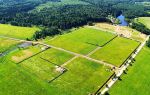
Currently, more than half of the land plots in different regions of Russia do not have official boundaries. Thus, if it is decided to sell the land plot, carrying out boundary measures will make it possible to establish the actual boundaries and obtain a document for the land. Without land surveying, state registration is not carried out. The procedure for determining boundaries is quite lengthy and takes several months.
Read here >> Pros and cons of land surveying https://migrant66.ru/zemlya/kadastr/nuzhno-li-delat-mezhevanie-uchastka.html .
If you are interested in transferring the boundaries of a site in kind without boundary signs or with it, and you would also like to learn about all the features of this process in Omsk, contact the experienced lawyers of our website. They will review your case and tell you what to do in a given situation. It is also possible to represent your interests in court.
Preparing for land surveying of a summer cottage
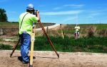
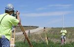
If an act of land surveying is required, you should start preparing by finding a land surveyor - a cadastral engineer who is trustworthy.
The accuracy of drawing up a plan for a privatized summer cottage and the duration of the process depend, first of all, on the professionalism of this specialist. Before signing a purchase and sale agreement, this procedure must be completed without fail.
The implementation of a new land survey of a summer cottage has the following stages:
- Collecting information about the allotment, analyzing the information that was received.
- The boundaries of the dacha plot are agreed upon with representatives of organizations, as well as individuals whose interests were affected by land surveying.
- A geodetic survey is carried out, after which its results are analyzed.
- A boundary plan is drawn up, then it is provided to the employees of the local cadastral organization.
- The landowner of a garden house receives a cadastral passport for his own plot, where his exact coordinates are indicated. Please note that the boundary plan is the only important condition in order to obtain a cadastral passport for the land.
- The plan should be certified with the seal/signature of the cadastral specialist who carries out the work. Then the document must be signed by all persons who have an interest in carrying out the land surveying procedure - the signatures of these people must be placed on the back of the papers in the graphic documentation of the land survey plan. In this case, the cadastral passport can be obtained ten working days after the documents have been submitted. The data is entered into the cadastre.
What difficulties arise when surveying a summer cottage?
Difficulties leave a certain imprint on the outcome of the completed survey, and also entail a refusal to formalize the results of survey work. Difficulties include:
- Identification of cadastral errors when performing boundary work. It happens that it is found in the designation of nodal points of the boundaries of the allotment. The problem can only be solved by repeating the land surveying procedure. The executor must be the organization that made the mistake. The work is carried out at her expense.
- Neighbors disagree with the results of the work carried out and the boundaries of the site that were established. In such a situation, recognition of the boundaries of the allotment is carried out only by applying to the court. But this can be done if, during the land surveying, all the necessary conditions were accurately met.
- It is necessary to clarify the boundaries of the site with its increased area, if this is possible in connection with the requirements of modern legislation. When drawing up a conclusion, the cadastral engineer must justify the need to increase the area within the limits established by the bill. Otherwise, legalization of the repeated survey will be denied.
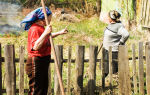
- It is impossible to transfer the boundaries of the allotment when carrying out land surveying from the plan to the actual location, the reason is the emergence of obstacles to the work (there is a permanent fence on the neighboring site, which makes topographic survey impossible, the allotment boundary runs along a water area formed in the recent past due to leaching soil).
How can a lawyer (lawyer) help?
If the boundaries of a site are transferred during land surveying, the following problems arise:
- boundary markers have been lost, so it is unclear where the boundaries are, especially if the plot borders a road, abandoned site or road;
- the neighbor's buildings are located in close proximity to your plot, the fence is high enough and shades your land, the neighbor's plantings have grown, having a negative impact on your cultivated plants;
- the boundaries of the site have been violated by a neighbor who has firmly established himself by installing a fence or planting green spaces;
- you are in the way of a power line, road, or other infrastructure that comes into contact with your property;
- the administration proposes a different site plan, violating existing boundaries and your interests.
The lawyer will carefully study the conclusion of the cadastral engineer received after the land survey, analyze the information and suggest what documents need to be drawn up, in what order, so that they fully correspond to the real state of affairs.
Here you can >> Ask a question to a lawyer on land matters .
A specialist will help you go through the procedure for registering land surveying in full compliance with the requirements of modern Russian legislation.
How to carry out land surveying for free under the “dacha amnesty”
According to the order of the Chairman of the Government, drawing up a new boundary plan with clarification of the boundaries of the site is possible completely free of charge until 2020 as part of the “dacha amnesty” program.
Land previously received for use can be legalized under the new law with minimal costs. Although it is still not known for sure whether land surveying of areas subject to this regulation will be carried out free of charge for landowners.
At the legislative level, there is a mandatory provision according to which all plots in dacha cooperatives and gardening partnerships, registered through a “dacha amnesty,” are subject to land surveying within a specified time frame.
Only the results of survey work provided by government bodies whose list of tasks includes work on surveying land plots of various categories of permitted use will be recognized.
The activities of such units are carried out free of charge for the population. Landowners only have to pay state fees for free land surveying of their dacha plots. Despite the complete lack of provision in the bill for land surveying to be carried out absolutely free of charge, this service can be obtained at low cost.
Prices for boundary work
When land surveying of a dacha plot takes place in SNT or within the city, the cost of the boundary mark and the work will be approximately the same. The price varies depending on the area.
Clarifying the boundaries of the site contains the following important steps:
- Work on the boundary plan, taking into account the information from the documentation for the allotment. The highest prices for such services in Moscow and the region are about 16,000 rubles, which depends on the complexity of the project.
- The boundaries of the territory are transferred to nature, and special boundary signs are placed at turning points. Here the price will depend on their quantity used when surveying the dacha plot. A copy of the sign usually costs around 500 rubles.
- Topographical survey of land to accurately determine the boundaries of the site directly on the territory. In Russia, the cost of services ranges from 4,000 to 8,000 rubles.
The remuneration for the work of a cadastral specialist is different in all companies and is a negotiated amount.