The procedure for drawing out the boundaries of a land plot and drawing up an act
Content
The land surveying procedure determines the boundaries of the land plot, which are fixed in the relevant documents. Thus, the owner receives an individually defined plot and the right to dispose of it. And fixing the identified boundaries is called setting out the boundaries of the land plot. And it involves installing boundary markers (for example, a fence) on the ground.
What it is?
Removal of boundaries involves the installation of boundary signs (MS), marking the boundaries of property, on a land plot. The entire list of geodetic procedures is applicable to standard landfills.
In this case, the placement of points is based on previously carried out surveying and information contained in the real estate register. If the owner does not have such information and, upon request, a negative response comes from government agencies, then in this situation the land plot is surveyed.
Setting out boundaries in nature determines the following results:
- obtaining accurate information about the plot area and shape;
- establishing boundaries that comply with regulatory documents;
- reliable determination of the location of the site on the ground and among other properties.
All this information is used to determine the value of the land plot, its features and characteristics and allow the plot to be used as efficiently as possible. In addition, when making any transactions with land, you will need documents for it.
You can get detailed information about the actions that people take when buying and selling a plot of land, including checking documents for legal purity, on the website. Ask a question to a lawyer in a special consultation window or call.
When is land surveying carried out?
The boundaries of a land plot are drawn in kind in the following cases:
- if the previous boundary signs are lost or moved without the knowledge of the owner of the site;
- information about the land is entered into the register and displayed on a public map, but in fact the site is not demarcated on the ground;
- the owner intends to erect fences or erect another structure on his property. For this purpose, the site is divided;
- in case of purchase or sale of land, boundaries are determined;
- owners of adjacent land plots carry out the land surveying procedure and draw up an approval act;
- the land plot is subject to change: division, allocation, annexation or merger. To carry out an accurate procedure, boundary signs placed on the ground are required.
Who does the work?
The work on setting boundaries is carried out by a cadastral engineer. Theoretically, you can determine the boundaries of the site yourself by studying the documents for the land plot and the boundary plan.
With the help of a tape measure and geometry, each owner will be able to transfer the configuration of the site to the terrain and set up a fence. However, this is only true for areas that have a simple or regular shape. For everyone else, making boundaries without the help of specialists will be extremely problematic.
Without special devices, the owner of the site will face the following problems.
- Firstly, the complex shape of the site, which is not easy to transfer to the ground. It will not be possible to solve the problem with a tape measure alone.
- Secondly, if the development area is new and there are no landmarks or a fence nearby, then it is impossible to determine exactly where the boundary lies.
- Thirdly, independent work has no legal significance. In these cases, specialists will have to be involved to remove the boundaries.
There are enough organizations and individual entrepreneurs providing cadastral services in all regions. In particularly large regions, it is difficult to choose one specialist due to the number of proposals.
You should not chase a low price: companies in Moscow and beyond offer to perform work at a cost below market value, but in fact it turns out that the organization is not a member of a self-regulatory organization (SRO), does not have suitable equipment and cannot provide services and work in the field of geodesy .
Criteria by which you can choose a performer:
- availability of permits;
- performance assessment (specialists on staff of the organization are considered more reliable);
- availability of equipment necessary for the work;
- cost of services;
- having your own website and office;
- positive reviews.
What is needed to carry out the take-out?
To draw out boundaries, you will need a cadastral extract, namely section KV.6 (catalog of coordinates), which includes the coordinates of each turning point. It is often confused with sheet KV.3, containing information about distances and directional angles between points.
Cadastral extracts are issued by branches of Rosreestr, which in the old fashioned way are called cadastral chambers (in fact, there are no such institutions anymore).
This document is prepared when cadastral registration is carried out. If an extract is missing, you can order it at the MFC and via the Internet , as well as from private companies specializing in the provision of geodetic services. pay a state fee for preparing a cadastral extract .
If the extract does not contain section KV.6, then the boundaries will have to be clarified. The coordinates contained in the extract are required by cadastral engineers to secure each turning point on the ground with a boundary marker.
Important! Take this process responsibly. It happens that due to a lack of experience or professionalism, performers make inaccuracies when surveying. As a result, the resulting documents and diagrams will contain errors.
See >> How to correct a cadastral error .
Work order
The work is carried out in stages:
- After selecting a contractor and receiving an extract from the Unified State Register of Real Estate, the owner of the site enters into an agreement. It includes: cost of work, deadlines, responsibility, list of works, results.
- Topographic survey of land boundaries and determination of coordinates. For this purpose, sophisticated modern equipment is used (GLONASS, GPS, satellite receivers), which makes it possible to establish the location of turning points on the ground. The kinematic measurement method is most often used; it is fast, accurate and modern. Turning points are determined using an electronic tachometer, and their location is marked by the position of a stick with a reflector. This stage is important, since further boundaries are removed from the base points.
- Drawing up an act of removing boundaries. In fact, this document is an atom of completed work. It is drawn up in two copies in advance and signed by the parties at the time of delivery and acceptance of the results. The act does not confirm the accuracy of the boundaries, but only the fact that the work was performed by a cadastral engineer.
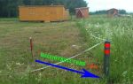
- Installation of boundary signs.
Boundary sign, what is it? This is an object that indicates the removal of points - the boundaries of the site. They are temporary and permanent.
Temporary signs are unreliable structures that are installed temporarily or have a low cost and limited service life.
Permanent - capital objects that mark the boundaries of the site. Their prices are higher.
The following may be used as boundary signs:
- metal pipe;
- wooden post;
- metal stamp with notches.
The listed signs are deepened by 80 cm or more depending on the type of soil. The installation of boundary signs implies an error of up to 10 cm from the points determined by the geodetic network. Modern devices provide just such precision of work. Information about the error must be included in the cadastral extract.
The timing of the work depends on the volume and workload of the contractor and can range from several days to a month.
Price
Work on the removal of points is carried out by specialized companies that have on their staff experts with appropriate education and narrow qualifications.
Due to the fact that geodetic services are very complex and require deep knowledge, the cost of the work is high.
How much it costs to determine boundaries on site depends on several factors:
- number of turning points: the more there are, the lower the price;
- square;
- urgency of service provision;
- prices set by a specific company;
- location of the site, including the region of Russia;
- completeness of information available to the owner.
Taking into account all the listed factors, we can conclude that the cost ranges from 500 rubles to several thousand per boundary sign.
Thus, in the Moscow region, installing four boundary signs costs about 9 thousand rubles. Preparation of additional documents is paid separately. These include photographic recording of the boundaries, a conclusion, a report.
What does the act of taking out into nature look like?
The removal certificate is drawn up in free form, since the legislation does not establish requirements for form and content. Each company has its own developed form of this document.
The contents of the act include:
- data from the extract from the Unified State Register of Real Estate, which is the basis for drawing out the boundaries of the land plot;
- square;
- location;
- diagram of boundary signs;
- information about the owner of the site.
The act is drawn up for the contractor and the customer and sealed with their signatures. It is often supplemented with photographic materials. Despite the fact that the act is a document, it is not proof that the boundaries were installed by a specialist, because they could have been rearranged, destroyed, or moved.
There are two ways out of the situation.
- The first involves the removal of boundaries with the participation of neighbors who put their signatures on the act.
- The second method involves photographing the results of the cadastral engineer’s work and preparing detailed documentation.
It may include:
- explanatory note;
- layout of turning points;
- coordinate directory;
- photographs of numbered boundary signs.
The removal of boundaries is confirmed by the examination of a cadastral engineer, drawn up in the form of a conclusion. In it, the specialist draws up a detailed report on the work done, attaches photographs, and answers questions regarding the correspondence of the actual boundaries of the site with those indicated in the cadastral extract. The conclusion is certified by the signature of the engineer and the seal of the organization.
Thus, removing the boundaries of a land plot is a procedure performed by cadastral engineers. It is permissible to install boundary signs yourself when the site has a simple geometric shape and there are no disputes with neighbors regarding land boundaries.
The error in installing boundary signs should be no more than 10 cm from the values indicated in the extract. The duration of the work depends on its volume and the remoteness of the land plot. The cost varies in the regions, but approximately you should expect an amount of 8 thousand rubles.