How to resolve a land dispute along the border of a plot
Content
Ownership of a plot of land presupposes accurate identification of the object. Sometimes the boundaries/area need to be clarified. Any land plot that is owned must necessarily have clearly defined boundaries. It is possible to establish the area where ownership rights are distributed. When a land dispute arises along the boundaries of a site, a boundary plan can be made. The work makes it possible to consolidate, restore, determine the area of the territory of borders and other information that is important.
All information received is reflected in special accompanying documentation. Land surveying is necessary to officially secure the land plot in Rosreestr. This case requires determining the characteristics of an existing object with which problems have arisen.
If you have disputes with neighbors regarding boundaries and you do not know how to resolve them, we recommend that you contact the professional lawyers of our website. You can talk about your problem and get advice - ask for help .
You can get advice from a lawyer on land disputes on each specific land issue, including the imposition of boundaries. Also, when necessary, they will provide sample documents or statements.
Be sure to consult with lawyers so that you don’t end up with a situation like the characters in the video presented:
Why do land disputes arise regarding the boundaries of the site?
Most often, the reasons for challenging and redefining boundaries between neighboring plots are:
- errors made by cadastral engineers during land surveying;
- contradictions in the available documentation (land management methods that were used before were not particularly accurate);
- unauthorized seizure of a certain territory of the disputed area by one of the neighbors.
Contradictions occur when boundaries are placed directly on the ground, as well as when acts on the approval of boundaries are signed. If it was not possible to reach an agreement with the neighbors, then a court decision on the land dispute is necessary in accordance with the Russian Land Code.
The last time the legislation on land territories changed was in 2016. In order to avoid litigation, then it became mandatory to coordinate the survey results with the persons who are the owners of neighboring plots.
In the event of a violation of boundaries, the person whose land rights were affected can protest the results of the procedure, even if they were included in the cadastral documentation.
Conducting examinations and assessments
Russian legislation does not oblige the state examination and the assembly of a special commission when deciding cases regarding land surveying.
In recent years, land management examination in 9 out of 10 cases is ordered by the court if the parties to the dispute did not have time to conduct it before contacting law enforcement agencies on their own initiative.
An examination of territories is carried out when current controversial issues arise in the event that a court considers a lawsuit filed by a person who owns one of the sites. The process goes in two directions:
- When checking the documentation is not enough to resolve land disputes along the boundaries of the allotment, a practical examination will be assigned. This work is carried out according to instructions from the Roskomzem organization, created in 1996. The components of the examination are in essence very similar to the standard land surveying process. The work is carried out by a cadastral engineer who has official permission to carry out geodetic work. This specialist also signs his own expert report, which will describe the results of the process. The deadlines for identifying the objective boundaries of plots are not established by the legislation of the Russian Federation, but they are defined in an agreement with the cadastral engineer.
- According to Article 6 of Law No. 78-FZ, which regulates land management, a state inspection of various documents, in particular cadastral documents, is carried out. Documentation on private plots is checked to determine the compliance of the site plan with the original boundaries. The technical conditions and requirements of modern Russian regulations are also checked. It is initiated by other persons, the local municipality interested in conducting it. The inspection is carried out by employees of Rosreestr organizations that work in the regions. No more than three months are allotted for this procedure from the date of acceptance of the research documentation.
Ways to resolve disputes
To prevent the matter from going to court, you must first try to come to an agreement with your neighbors regarding a solution to the conflict. If for certain reasons it was not possible to voluntarily resolve the conflict to clarify the boundaries, then it is necessary to go to court.
You should proceed as follows:
- a cadastral error in the register that is of a technical nature, it is worth sending an application to Rosreestr with a wish to correct it on the basis of Article 61 of Federal Law No. 218 . If necessary, documentation is added to it that proves the applicant is right. Within 3 days from the time the documents are accepted, the registration authority is obliged to decide how to correct the defect or determine the reason for the refusal.
- Clarification of the actual border of the site, its position on the ground in relation to neighboring plots. The procedure is necessary to defend one’s own opinion in court or to provide evidence to neighbors regarding the real state of affairs. To carry out a new survey, a cadastral engineer is hired. A special agreement is concluded with him. The specialist must perform the actions indicated in the instructions from Roskomzem for 1996. Also, instructions for the procedure are available in the Methodology of Roszemkadastr (2003).
If the notification was sent and received by all neighbors on the land plot with the disputed territory, but some of them did not come to the land survey, they will receive a message regarding when and where the act can be endorsed.
Read also >> How the act of approving the boundaries of the land plot is drawn up .
If there is a subsequent failure to appear, the paper may be approved without them. It happens that some neighbors do not want to agree on the boundaries of an adjacent plot, then jurisdiction is relevant - the dispute must be resolved through the court.
A statement of claim is being drawn up. According to it, the defendant will be the owner of the adjacent plot, who prevents the preparation of the necessary cadastral documentation, in particular, the boundary plan, deed, and other things.
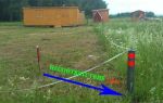
During the land surveying process, boundaries are established directly on the ground, after which a special approval act is drawn up. It is signed by persons interested in a land dispute regarding the coordination of boundaries on the ground.
The act must be signed by all persons involved in the dispute. They are also notified regarding the procedure for delimiting the territory seven days before its start.
Land management expertise in boundary disputes is of great importance. The resolution of a land dispute between neighbors is carried out using a technical process to determine the boundaries of the plot.
The party that wants to conduct an examination must necessarily formulate the main questions so that the experts’ answers allow them to understand all the nuances of the current situation.
An examination is appointed at the request of any party to the dispute. Judicial authorities can also initiate the process. The disadvantage of the procedure is its high cost. If the standard land surveying process costs about 10,000-15,000 rubles, then for an expert study you will have to pay up to 40 thousand rubles.
If border disputes with neighbors cannot be resolved, then you need to go to court with a claim. A land lawyer will help you draw up a statement of claim, taking into account all the features of the case.
Which court considers citizens' appeals?
The statement of claim is filed with the court on a territorial basis, that is, in the place where the site is located. The tasks of the magistrate include resolving various disputes that relate to identifying the order of use of property, in particular land plots.
Various disputes regarding land surveying are resolved by the district court. He also establishes the territorial perimeters of the allotment.
Limitation periods
The general provision regarding the limitation period of three years applies to all conflicts concerning plots. At the same time, it begins to be calculated from the period when the applicant is aware of the occurrence of circumstances due to which his rights are violated.
In some cases, during judicial practice and consideration of cases concerning land disputes, it is quite difficult to determine the exact date of violation of the rights of the person who filed the claim. The time for consideration of a claim may be increased by court decision.
Examples from judicial practice
Disputes about the boundaries of neighboring areas are resolved in the courts, which often make mistakes, expressed in non-compliance with the existing established procedure.
For example, the judicial panel of the region. The Penza Civil Court overturned the decision of the Leningradsky District Court of Penza, adopted on 10/22/2013. The basis for canceling the decision was that the persons owning the adjacent plots did not take part in the consideration of the case and the change of boundaries.
In this case, an important factor in the decision was the analysis of all the evidence in the case, carried out with the utmost care.
The evidence base includes witness testimony, archival materials, soil differences, placement of buildings, etc. Since resolving the essence of a land dispute requires special knowledge, in this case the examination will become an important piece of evidence.
If the title documents do not indicate the boundaries of the plot, then the boundaries are recognized as lines that were formed 15 or more years ago and were fixed with the help of artificial/natural objects. This also applies to plots that were delimited about 10 years ago - at that time the measurements were not particularly accurate.
All disputes in the courts regarding land plots always end with the adoption of decisions. Based on them, data on the boundaries of plots can be clarified, after which accurate information is entered into the Cadastre.