Why is it necessary to establish land boundaries?
Content
Not a single plot of land can be registered with the cadastral service and registered as a property without first carrying out a land surveying procedure. Therefore, establishing the boundaries of a land plot in a manner regulated by legislative norms is mandatory for all citizens who want to confirm their rights to a property of this type. The location of boundaries often becomes the cause of disputes, which can only be resolved with the help of an experienced lawyer.
Why do this?
A plot of land is an individual piece of real estate that can participate in purchase and sale transactions, pledge, sale and be used for its intended purpose. Identification of cadastral boundaries on an area makes it possible to privatize a garden plot and register it as property.
Since the land surveying procedure is always agreed upon with other landowners and third parties related to the site, it is not always possible to reach an agreement peacefully. Sometimes the help of a lawyer is the only way out of a difficult situation. If a controversial issue arises, you can get detailed advice on the website.
Important! Establishing and agreeing on the boundaries of a land plot using land surveying helps prevent controversial situations and disagreements. This procedure confirms the legal status of the property and gives its owner the right to dispose of it as personal property.
The procedure for determining the boundaries of a land plot is carried out by submitting an application to local authorities from the owner or other persons. The coordinates of the storage facility are determined taking into account the regulations set out in Article 38.7 of the Federal Law of the Russian Federation, as well as the instructions and set of rules specified in the law.
It is necessary to establish correct and precise boundaries if the property was not previously registered with Rosreestr or information about it was lost. Land surveying is also recommended in order to resolve disputes and clarify the limits of artificially created or protected zones.
Read more >> Resolving disputes between neighbors during land surveying.
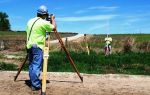
The procedure is carried out by a commission to clarify the boundaries of land plots, headed by an engineer, which operates in accordance with the Land Code of the Russian Federation. After surveying, information about the location of the land plot and its limits is entered into Rosreestr.
Since 2018, owners of plots without clearly established boundaries will not be able to conduct any operations with their territories. Their actions will be declared illegal, and their rights to the land will lose their validity.
Land surveying is necessary for the following types of transactions:
- sale, purchase or lease of storage units;
- land donation and exchange;
- registration of property rights;
- division of land between several owners;
- combining several plots into one.
Rules for the procedure
The rules for surveying and establishing the boundaries of a site are set out in detail in Federal Law No. 221 and 122, taking into account which cadastral service employees carry out this procedure under the guidance of an engineer.
All stages relating to standards, determining the accuracy of measurements, the procedure for carrying out geodetic and cadastral activities are described in the State Real Estate Cadastre, which is now called the Unified State Register of Real Estate (USRN).
A request for approval and establishment of the boundaries of the property is submitted after writing an application in the established form. In addition, you will need an act stating that the neighbors do not object to the approval.
Important! The act of establishing and agreeing on the boundaries of the land plot is drawn up according to the form and is concluded only taking into account the opinions of the neighbors, who must familiarize themselves with the conditions and sign.
The procedure for establishing the boundaries of a plot of land and the land surveying procedure consist of three separate stages, the first of which is the preparation and planning of survey work. At the second stage, a geodetic study and topographic survey of the area are carried out.
After this, the engineer carries out office work and prepares a land surveying report, to which the finished landfill plan is attached. After completing the procedure, the engineer must submit the land surveying project to Rosreestr in a scanned form, a paper copy with the boundaries of the land plot is given to the customer.
The procedure for establishing the boundaries of a land plot
In the process of clarifying the boundaries of a land plot, a coordinate system is used, where geographical and other indicators in kind are indicated. This information is transferred to a single cadastre and relied on when determining the territory of a particular land plot on the ground.
Cadastral service employees often make technical and other errors that can be corrected within the required time frame, taking into account the law of the Russian Federation. The owner of the land can adjust its limits at any time if an inaccuracy is detected.
Read more >> How to correct a cadastral error .
Important! If there is a public land easement 1201, the owner will be limited in the rights to use the site in favor of third parties. This fact is also taken into account when restoring the boundaries of the land.
This is necessary when determining the exact coordinates of the plot, in the case of establishing information on land surveying, as well as during disputes in court regarding adjacent plots.
To establish or clarify boundaries, the land owner is allowed to change the turning points of the plot and clarify its territory; in the first case, the size of the plot often increases by about 10%.
Establishing actual storage limits consists of the steps outlined below:
- Detailed study of the condition and composition of the soil, identification of owners of adjacent territories.
- Creation of new or modification of existing land areas by drawing up plans or schemes for land surveying.
- Discussion of controversial issues and coordination of territories with owners of land plots, government officials and owners of adjacent territories.
- Fixing the allotment in Rosreestr and creating a personal number for it.
- The procedure for determining the boundaries and exact limits of the territory.
Required documents
In addition to the application to establish the boundaries of the land plot, the landowner who wants to privatize a garden plot or other type of land will need to provide a full set of documents.
Their list includes:
- Passport of the owner himself or a person working under a power of attorney.
- Documentation for the land plot, including the act of approving the location of the border of the land plot.
- Ready land plot plan.
- A certificate confirming the change of information in the Rosreestr of the Russian Federation ( extract from the Unified State Register of Real Estate ).
- Act and boundary plan for establishing the boundaries of the land plot.
Drawing up a statement of claim
During the procedure for establishing the actual boundaries of adjacent areas, serious conflicts often arise, which can only be resolved in court.
It is usually necessary to submit an application to resolve the issue of limits after they have been violated on a certain land plot, including errors and omissions during cadastral control. The main argument for the plaintiff is always the land survey plan drawn up in accordance with the rules for establishing the boundaries of the land plot.
The plaintiff must correctly present the information using the sample statement of claim to establish the boundaries of the land plot. You can do this yourself or with the help of an experienced lawyer. The application is written by hand or typed on a PC; you will need to indicate the facts of the case and your requirements in as much detail as possible.
In addition to the statement of claim, you will need a list of supporting documents, including land survey and territory plans, an extract from the cadastral register and passport, and a check for payment of the fee .
Arbitrage practice
In order for the court to consider the case to establish the location of the land limits, it will be necessary to determine the jurisdiction of the claim. The application is submitted at the location of the land plot; you must always pay attention to the statute of limitations.
In land law and in practice in establishing boundaries, this period does not exceed 3 years. If the limitation period has been exceeded, the court has the right to refuse to consider the case to the plaintiff. Therefore, the exact period should always be calculated in advance.
Important! The countdown of the deadline begins differently, taking into account each specific case. When it comes to appealing the procedure for establishing the boundaries of a previously registered land plot, the countdown begins from the moment when the plaintiff becomes aware of the existence of controversial issues.
For good reasons, the statute of limitations can be restored for the plaintiff, for example, if he served in the army, was on a long business trip, or was treated in a medical institution. This fact must be declared 6 months before the expiration of the statute of limitations.
In such a situation, the plaintiff can file a claim to establish the boundaries of the land plot, a sample of which can be downloaded on the website . The determination of the jurisdiction of disputes and the final decision of the court are made after a detailed consideration of the case.
Cost of work
Work to establish boundaries on a land plot is paid taking into account a number of factors. This cost includes the transport costs of the cadastral company, but does not take into account the payment for boundary markers. On average, the land surveying procedure costs at least 8,000-9,000 rubles, not counting additional expenses.
The total price for the project to establish the boundaries of the site depends on such items as:
- location of the site relative to the populated area;
- problems with the terrain, the presence of various obstacles that interfere with the work;
- the general dimensions of the area where the work is being carried out;
- availability of an extract from the State Cadastre or cadastral passport, which is still relevant.
Here is an example of a price list for the services of one of the companies in Rostov-on-Don.
The boundaries of the site are indicated using special signs and construction tapes; there are other methods of marking: metal or wood stakes, permanent boundary and anti-vandal signs. The establishment of the demarcation line for land plots is carried out after an examination in accordance with the relevant instructions.
The period for establishing part of the boundary of the site will depend on the total scope of work and the territory of the land plot for actual use. Cadastral service employees will carry out the procedure taking into account the regulations, including the requirement to establish boundaries and other nuances that may arise in the process.