How and for what purpose is the restoration of the boundaries of a land plot carried out on the ground?
Content
Often the boundaries of land plots are violated due to fraudulent actions of third parties or simple misunderstandings. Then it will be relevant to restore the boundaries of a land plot as the most effective method of protecting the rights of the owner from various offenses that arose due to the actions of intruders.
This procedure is carried out in a pre-trial/trial form. The result is entering data into the boundary plan, as well as installing special boundary signs directly on site.
Land plots can be recognized as independent real estate objects from the period of their receipt, as well as the identification of various important indicators. First of all, restoration of the boundary boundary of a plot of land is carried out by establishing characteristic points of the boundaries of a certain plot in the village plan.
They must be agreed upon with the owners of neighboring plots. This procedure will make it possible to delimit individual plots prior to cadastral registration with the subsequent consolidation of ownership.
Until 2013, the boundaries of land plots were determined by BTI employees. They also fixed them on the ground. After the cadastral registration system was put into effect, these powers began to belong to cadastral engineers.
Today, the definition of boundaries is carried out as follows: cadastral and boundary work are carried out in a complex. In this process, engineers carry out all the necessary actions on the ground, and then transfer the results into electronic, paper title documents.
The results of cadastral work are entered into the boundary plan. At the request of the owner, boundary signs can be placed on the site. In order for cadastral registration to be carried out in Rosreestr, the basis may be a boundary plan. Only after this the plot can receive its cadastral number.
It turns out that the legal meaning of determining boundaries lies in the ability to make correct documentation for a land plot, as well as obtain a full range of rights, which will allow protection from various offenses and fraudulent actions of attackers.
Restoring boundaries is a procedure that allows you to confirm that a site has previously defined boundaries, as well as re-fix them on the ground and in documents that have legal force. The authority to prepare papers for this process belongs to cadastral engineers. In some cases, the owner must file a lawsuit in the Supreme Court of the Russian Federation to resolve the problem.
If you do not know how to file a claim to restore the boundaries of a land plot or want the court’s decision to correct a cadastral error to be in your favor, then you cannot do without the help of qualified lawyers. You can find specialists with extensive experience in our company.
Read also >> How cadastral errors are corrected .
You can get a consultation on the website - here , by phone and at an individual appointment. A specialist will look at the specifics of your situation and tell you what to do to ensure the optimal solution to the problem. If disputes arise, lawyers are ready to represent your interests in court in the Moscow region.
Legislation of the Russian Federation
The establishment and restoration of the boundaries of land plots is carried out taking into account the general requirements that are established for various works on geodesy and cadastre.
Regulation at the legislative level is carried out by the Land Code, the Federal Law entitled “On Cadastral Activities”. The provisions of other regulatory and legal documents relating to this procedure are also taken into account. For example, these may include:
- government regulations;
- regional/federal laws;
- ministerial orders;
- regulations, standards (state), etc.
If a statement of claim should be drawn up, then the provisions of the modern Civil Procedure Code will be used. The requirements for drawing up court claims, the specifics of their filing, and the entry into force of all court decisions are taken into account.
The meaning and reasons for the work
The most popular motive pushing people to restore actual boundaries is the protection of their property rights in real estate, including from attacks by fraudsters. When misunderstandings arise with neighbors regarding the limits of the allotment, then this procedure simply cannot be avoided.
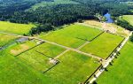
Restoration of the boundaries of a land plot according to cadastral data is a process during which the legal boundaries confirmed in special documentation are restored on the property.
When restoring boundary signs, a specialist, using specific methods, determines the location of the boundaries of the allotment, and also fixes their actual location. Using a site without properly recording and documenting its boundaries is in some cases unacceptable.
For example, a plot of land is expected to be sold, and the new owner wants to see the specific boundaries of the land being purchased. Placed boundary marks are a more visual method of land surveying than the usual recording in documents, so in most situations it is not possible to do without boundary marks.
Sometimes boundary markers on the ground were damaged, lost, or disappeared. They are considered the main identification structures that define the boundaries of the plots.
If for some reason they are not on the boundaries of the site - there are no enclosing structures, fences, plants, then in this case the owner is simply obliged to order a special procedure for removing the border from the area.
It is necessary to plan a site when there are disputes with the owners of adjacent sites. For example, some of them have taken part of a neighbor's plot or believe that it is being illegally used as part of their land.
If it is not possible to agree on resolving the issue voluntarily, in this case only an appeal to the court will help. But before the trial, it is important to restore the exact boundaries on the ground. The decision on restoration made by the court will protect the property rights of the two parties and prevent future disputes regarding the boundaries of the plot.
Recovery procedure
When the neighbors in the area have signed an act on the coordination of boundaries , then subsequent settlement of the dispute is possible without judicial practice.
The boundaries that have been confirmed in this way will be necessarily marked on the ground by installing boundary signs along the boundaries of the area. In turn, the owner will be given an extract from the state register of the Unified State Register of Real Estate , where the boundaries are recorded on a graphical diagram.
For each landowner, the restoration procedure is as follows:
- conclusion of a contract agreement with a cadastral engineer, which determines the timing and purpose of carrying out boundary work;
- the landowner must provide the specialist with the entire package of title documents for the land, give access for inspection and measurements of the site;
- during boundary work, characteristic border points will be identified, information that was previously entered into the State Register of the Unified State Register will be taken into account;
- Based on the results of the survey, all information received regarding the boundaries must be agreed upon with the owners of neighboring plots;
- If agreement is reached with all owners of adjacent plots, a boundary plan is made to be included in the Unified State Register data.
Preparation
The landowner organizes the process of restoring the boundaries of the land plot:
- searches for a highly specialized company performing similar work;
- finds out detailed information about the selected contractor (methods, tools, cost of services, work experience, and so on);
- signs a contract with a specialist or company, which describes in detail the terms of the agreement;
- prepares a package of documents (according to the list of required documents), and then provides them to the company performing the work;
- makes an advance for the work.
Then the prepared documentation is given to a cadastral engineer who carefully studies it. Only after this the engineer becomes familiar with theoretical materials and moves on to a set of practical works.
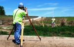
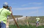
Field stage
Cadastral engineers, using special tools and coordinates that appear in the extract for the allotment, determine and fix its turning points (indicate the direction directly from the boundaries of the allotment).
It is important to note that any turning point is fixed by elements intended for this purpose - boundary signs, used permanently or temporarily.
If we take into account the climatic features of the area and the individual wishes of the client, these elements can be made of metal or wood. It is recommended to preserve the signs in the future, since they are the main identifying elements of the boundaries of the plot. They can also be replaced with a fence or plant fencing.
Office stage
This stage is the final one. Here the contractor needs to prepare some documents: an act of removing all boundaries to the area, a photo report of the work that was done. A certificate of completion of work (acceptance and transfer) is also drawn up and signed by the parties.
Then the owner receives absolutely all the documents needed to resolve the issue. The next important step is going to court. In this case, the owner must draw up a special statement of claim.
Filing a claim for restoration
The results of the court hearing and the outcome of the case depend on how completely the plaintiff presented information and collected documents. Sometimes the court establishes as important the examination procedure by independent companies. Its payment is made by the party that lost the dispute. The hearing will be held after all fees and charges have been paid.
A sample application for restoration of the boundaries of a land plot can be obtained from a lawyer. The complete list of documents depends on the specific situation. However, the more papers the plaintiff files, the higher the chance that the city court will rule in his favor. The landowner needs to make a lot of effort to prove the fact that the plot with clearly defined boundaries is his property.
The court's decision
Based on the results of court proceedings, a decision is made that is subject to mandatory execution by all authorized parties.
This is what a judicial decision looks like in one of the cases under consideration.